Click on the date to learn more about the item for that day
Posted around 8 pm Eastern so that everyone has plenty of time to have opened their calendar.

We included a Christmas tree because of our traditions today, not because they were seen in homes in America during the Revolution. In fact, it wouldn’t be until many years later that Christmas trees became popular here.
“German settlers also introduced Christmas trees in the United States, though the custom was not initially embraced. Many Puritans opposed the holiday because of its pagan roots, and officials of the Massachusetts Bay Colony actually outlawed celebrating Christmas. Their dislike of the holiday was such that they even closed their churches on December 25. It wasn’t until the 1820s that Christmas began gaining popularity in America, and the country’s first Christmas tree reportedly was displayed in the 1830s. The Christmas tree’s popularity spread with the help of the influential magazine Godey’s Lady’s Book, which in 1850 published the 1848 illustration of the British royals, though the depiction of the family was altered to appear American. This and other efforts helped make Christmas trees popular in the United States by the 1870s.”
Source: Britannica

“On December 30th, a British force under Lord Cornwallis attacked the Americans at Trenton, but failed to retake the town. Washington left a token force in the town to light numerous campfires, fooling Cornwallis into thinking that Washington had decided to make a stand in Trenton. In reality, over the next couple of days the Americans stealthily moved most of their forces around the British positions.”
Source: Historical background on the map, “Plan of the Operations of General Washington, against the King’s Troops in New Jersey, from the 26th of December 1776, to the 3d. January 1777, by William Faden,” in the The Barry Lawrence Ruderman Map Collection at Stanford.

The pewter stein was a common drinking vessel of the time, used for beer, cider, or other beverages.
However, contrary to what one sometimes hear, the Hessian soldiers were not drunk that night.
“Hessian commander Johann Rall suspected an attack and kept his troops on high alert. One Hessian soldier recorded in his journal they slept at the ready in their clothes. Reports that the Hessians were caught drunk or sleeping on the night of the attack are false. These rumors spread in the British press after the attack to discredit the Continental Army’s success. Though the Americans arrived long after dawn, the raging storm provided cover and they gained the advantage. The Hessians were surrounded, and a battle ensued. Soon, the Hessians surrendered nearly 1,100 troops and sustained 22 dead and 83 wounded. The Americans only suffered 2 dead and 5 wounded.
Source: The American Revolution Institute
More on the advance notice that the Hessians had received:
“Lurking within Washington’s headquarters was a British spy who has never been identified. This spy was privy to the early deliberations of Washington’s war council and correctly passed along to British Major General James Grant that Washington’s army was looking to attack north of the river. Grant passed along this information to General Leslie and Col. Von Donop who then passed it along to Col. Johann Rall at Trenton. And while Grant stated that he did not think Washington would attack, he did command Rall to be vigilant. Rall acknowledged receipt of this important intelligence at about the same time that Washington was beginning his crossing. With typical Hessian bravado, Rall dismissed or even welcomed the threat stating ‘Let them come… Why defenses? We will go at them with the bayonet.’
The day before, Rall had received two American deserters who had crossed the river and told the Hessians that the American army was ready to move. Other loyalists informed the Hessians that an attack was imminent. So why wasn’t Rall more active in opposing the crossing or better prepared to defend the town? History records that a series of false alarms and the growing storm had given the Hessian defenders a sense that no attack was likely that night.
Source: Mount Vernon
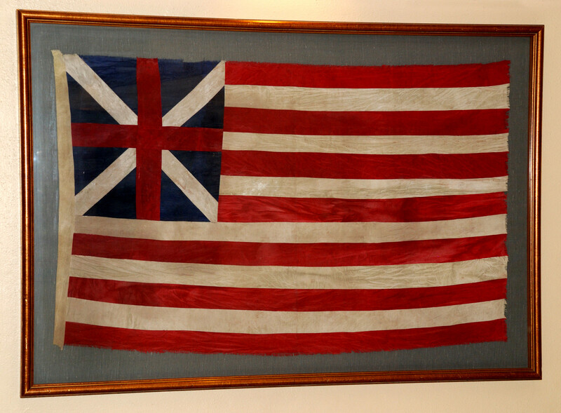
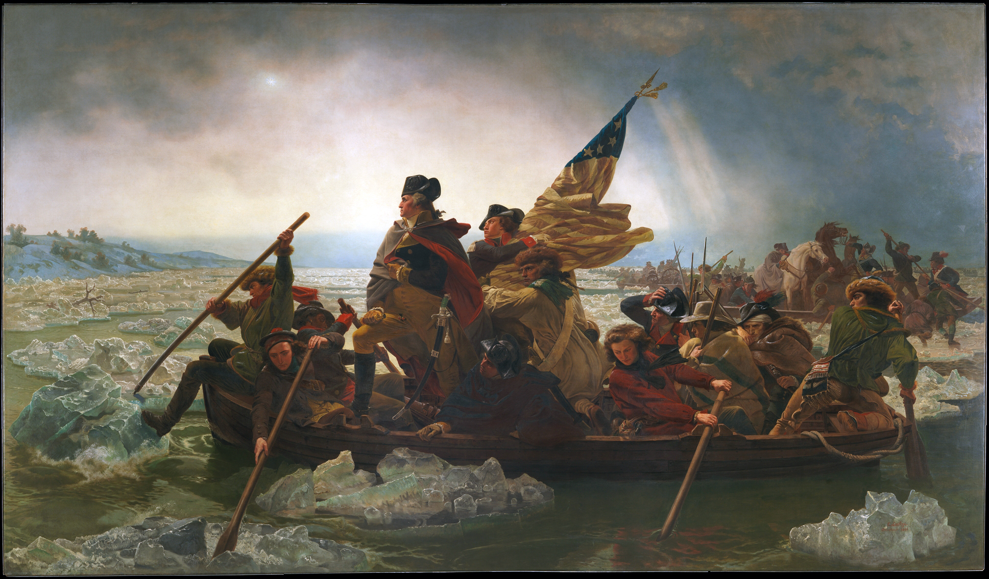
 The U.S. flag, or the early American flag, did not play a prominent role during Washington’s Christmas Crossing of the Delaware, as it was not yet the established symbol we recognize today. At that time, various flags were used by different regiments and militia units.
In the painting, the flag is held by 18 year old James Monroe, the future fifth president of the United States who was almost killed in the attack.
“Monroe suffered a severe injury during the skirmish when a musket ball hit him in the shoulder. Monroe would have died, had it not been for a doctor, who tied his severed artery immediately after the wounding. For his bravery in the campaign, Washington made Monroe a captain. After the New York and New Jersey campaigns, Monroe returned home to recruit.”
Source: American Battlefield Trust
See: The Museum of the American Revolution in Philadelphia and the American Revolution Museum at Yorktown have flags from the Revolutionary War.

The map of the crossing that’s shown on the mailing envelope is a British map:
Plan of the Operations of General Washington, against the King’s Troops in New Jersey, from the 26th of December 1776, to the 3d. January 1777, by William Faden
It is in the The Barry Lawrence Ruderman Map Collection at Stanford, which has this description:
“Fine early color example of Faden’s plan of the American Revolutionary War Battles of December 1776 and January 1777, including Washington’s crossing of the Delaware River, on Christmas Day, 1776, one of the most important early battles of the American Revolution. Published just weeks after the last of the battles, Faden’s plan depicts a roughly 400 square-mile area of New Jersey and northern Pennsylvania. It documents key events of the Trenton-Princeton operation, including the crossing of the Delaware on December 25, 1776, the attack on Colonel Rall’s force at Trenton on the December 26, 1776, Cornwallis’ rush south from Fort Lee, and Washington’s end-around to hit Cornwallis’ flank at Princeton on January 2-3, 1777. Faden’s plan appeared only three months after the battles and probably just a few weeks after the news reached London. It is hard to overstate the impact it must have had on the British elite, who after the capture of New York had anticipated a swift and successful conclusion to the war. The map illustrates the Theater of War northeast of the Delaware River, depicting two important early American victories, which helped gain critical support and momentum for the American Revolution.”
There is additional detailed historical information on the map and the events depicted on the map page at Stanford.

“Coonskin caps were originally worn by some American Indians as a traditional article of clothing; however, European pioneers that settled in the Tennessee, Kentucky, and North Carolina regions in the 18th and 19thcenturies adopted it as their own and wore them as hunting caps. Even Benjamin Franklin, in his trip to Paris as Ambassador to France, wore a cap as a symbol of patriotism. Its rough-hewn look has become an iconic part of the American frontiersman’s image.”
Source: National Museum of American History, which also describes the mid-1950s craze that saw sales of 5,000 caps per day.

“Under the overall command of Col. Henry Knox, the Continentals brought 18 cannons over the river – 3-Pounders, 4-Pounders, some 6-Pounders, horses to pull the carriages, and enough ammunition for the coming battle. The 6-Pounders, weighing as much as 1,750 pounds were the most difficult to transport to the far side of the river. But in the end, all the trouble of moving this large artillery train to Trenton proved its worth. Knox would place the bulk of his artillery at the top of the town where its fire commanded the center of Trenton.”
Source: MountVernon.org

The American Battlefield Trust has a short video on quill pens.
You can buy or make your own quill pen and discover how it’s much more challenging to write with than the ball point pens you may be used to.

Here’s the history behind this design:
“Before large wigs became popular for men during the late seventeenth century, low-crowned, large-brimmed, plumed, or feathered, hats were worn. As wigs increased in size, plumes disappeared and the brims of hats were cocked up. When the brim was folded up in three places, the hat became a tricorne, a three-cornered hat. Generally dark in color, tricornes were often edged with a gold braided trim after about 1675. Worn with one point forward, the tricorne hat emerged as the most fashionable hat for men in the late seventeenth and most of the eighteenth century. To be most stylish, men cocked, or tipped, their tricornes to one side or another. The origins of the tricorne hat go back to the battlefield, when soldiers wearing broad-rimmed hats pinned the sides up in order to channel rainwater away.”
Source: Fashion History Timeline
Today you can buy a well-made tri-corner hat of the kind that many men wore at the time of the Revolution.

One of Washington’s uniforms is on display at the National Museum of American History.
“This uniform was worn by George Washington from 1789 until his death in 1799; the small clothes, or breeches and waistcoat, date from the revolutionary period.
Washington often posed for life portraits during this period, and was often depicted wearing this uniform. An example is the watercolor portrait on ivory painted by John Ramage in 1789; it is the first known depiction of this uniform in a portrait of Washington.
“In December 1798, Washington was recorded wearing this uniform when he visited Philadelphia on Provisional Army duty. He wore a similar uniform when he was commissioned by the Continental Congress as commander in chief of the Continental army.
“None of his uniforms from the Revolutionary War period are known to have survived.”
Read more at the National Museum of American History.

Several of the swords Washington owned are on display at Mount Vernon. Other Revolutionary War swords can be seen at the Museum of the American Revolution in Philadelphia and the American Revolution Museum in Yorktown.

Park Ranger and Revolutionary War expert David Lawrence describes the different types of firearms and weapons that were used by the Americans and the British during the Revolutionary War in this excellent four minute film from the American Battlefield Trust.
Arms from the period can be found in many museums, including in Washington Crossing, Philadelphia, Yorktown, and Fort Ticonderoga, among others.

Also known as the Commander-in-Chief standard that marked General George Washington’s presence in camp or on the battlefield during the Revolutionary War. It helped messengers locate Washington and was probably carried by a mounted aide who rode alongside him on the march.
Source: Museum of the American Revolution

“ . . . the word “cape” usually refers to a shorter garment and “cloak” to a full-length version of the different types of garment . . .”
Source: Wikipedia
“George Washington wore a cloak to keep warm. The famous painting of Washington crossing the Delaware River before the battle of Trenton shows Washington wearing a cloak over his uniform, and other paintings depicting scenes from the American Revolution show Washington wearing a cloak while astride his horse during the battle of Trenton and at Valley Forge during the winter encampment.
“President Franklin D. Roosevelt preferred a Navy cloak to an overcoat. A picture taken on election night 1944 shows him sitting on his porch wearing his cloak while awaiting election results. The cloak touches the ground because he is sitting, and it has a loop closure a few inches below the top.”
Source: Alliance Review

Considering the soldiers, Washington Crossing National Historic Park explains:
“While shoes may seem like a necessity for soldiers, some units were left barefoot going into the Christmas Day Crossing and the harsh winter of 1777-1778 until the government was able to supply them with proper footwear.
“When they had them, men wore buckled shoes that were often affixed with gaiters: a canvas or leather covering worn over the ankles that kept out dirt and water. In order to travel through heavy snow and ice, cleats known as ice creepers could be attached to shoes with a leather strap.
“Longstockings made of wool or linen were worn by the average soldier all year round. “Lacking the elastic used in today’s socks, they were held up with a garter or string.
Source: WashingtonCrossingPark.org
A year later the situation hadn’t improved much.
Valley Forge National Historical Park uses excerpts from reports to describe Washington’s men as they made their winter camp at Valley Forge:
“Just eleven days later, Major General William Alexander (Lord Stirling) reported:
“above one half of those in Camp are […] walking barefooted on the Ice or frozen Ground.”
“This corresponds with Washington’s December 23, 1777 letter to Henry Laurens, the President of the Continental Congress. In it, Washington wrote:
“A number of Men [remain] confined to Hospitals for want of Shoes, & others in Farmers Houses on the same account, we have by a Field return this day made, no less than 2898 Men now in Camp unfit for duty, because they are barefoot and otherwise naked” (i.e., without a complete uniform).
“This comprised nearly one quarter of Washington’s army.”
Read more at the Valley Forge National Historical Park site.

Used on the frontier to carry supplies, such as food and ammunition. As with the coonskin cap, the artist probably included this to indicate the varied backgrounds of those fighting for the Patriot cause.

While we assume that drums were not used on the march since the plan was to surprise the Hessian troops stationed at Trenton, drums were used in war at that time to signal commands, keep the rhythm for marching, and rallying the soldiers.
Watch: While this is a ceremonial performance from the United States Army Old Guard Fife & Drum Corps at a “Tatoo” in Basel and not intended to be a reenactment of what might take place on a battlefield, it does show what this type of drum generally looks and sounds like. (We selected this clip because it’s nicely done and there’s no annoying series of commercials you have to sit through in order to watch it.
https://www.youtube.com/watch?v=hp92lJTMHTA
And just what is this type of “tattoo”? Here’s the explanation from Wikipedia, including the origins of the word:
“A military tattoo is a performance of music or display of armed forces in general. The term comes from the early 17th-century Dutch phrase doe den tap toe (Dutch for “turn off the tap“), a signal sounded by drummers or trumpeters to instruct innkeepers near military garrisons to stop serving beer and for soldiers to return to their barracks
See: This drum from 1740 at the Museum of the American Revolution in Philadelphia

“Under the leadership of Col. Henry Knox, the Continental Army successfully transported 18 cannons across the icy Delaware River. These included 3-pounders, 4-pounders, and the heavier 6-pounders, some weighing up to 1,750 pounds. Hauling these massive artillery pieces, along with horses and ample ammunition, was an extraordinary challenge, especially given the treacherous conditions. Despite the difficulty, the effort proved invaluable. Knox strategically positioned the majority of the cannons on higher ground overlooking Trenton, where their firepower dominated the town’s center and played a decisive role in the battle.”
Source: Mount Vernon
See: Washington Crossing Historic Park has a Revolutionary War era cannon on display, though it wasn’t used in the attack on Trenton.

Washington’s forces brought about 50 horses across the river. The horses were used for transportation and to haul the artillery pieces and their carriages.
Source: WashingtonCrossingPark.org

“A tam o’ shanter . . . is a name given to the traditional Scottish bonnet worn by men. The name derives from Tam o’ Shanter, the eponymous hero of the 1790 Robert Burns poem.”
“People of Scottish descent also made up a significant proportion of the early American population and the soldiers who chose the Revolution. Notable naval captain John Paul Jones, Declaration signers James Wilson and John Witherspoon, and military officer Hugh Mercer were all born in Scotland and chose the Revolution at its beginning. . . .
“Hugh Mercer was born in Aberdeenshire and served with the Jacobites in 1745 before fleeing to America. He fought with provincial (colonial British) forces in the Seven Years’ War and then as an officer under Washington from the beginning of the Revolutionary War. In the midst of the Battle of Princeton in 1777, he was mortally wounded by British soldiers. Years later, his son painted the scene of his father’s death, based on an earlier painting by James Peale.”
Learn more about the Scottish in the American Revolution at the Museum of the American Revolution
Additional source: Wikipedia for the explanation of the cap

“Originating in the small Bucks County town of Durham, Durham boats were significant because of their flat- bottomed design. In shallow, Eastern waters this allowed for the carrying of large loads of cargo, including troops. Measuring sixty-six feet long, six feet wide, and three feet deep; these boats held up to seventeen tons while only displacing twenty inches of water. They were double-ended, meaning they were sharp at both the bow and the stern, allowing for swifter navigation. Forty soldiers comfortably fit in the Durham boat, along with their equipment and a crew of six men to propel the vessel. Crew members used oars along with a steel pole that would be dug into the river bed, while one crewman held the opposite end against his shoulder as he walked from the bow to the stern. This was the most efficient way to navigate the waters.
“Durham Boats hauled many products during their time on the Delaware, including shot in the Revolution.
“In its original function, the Durham boat was used daily to support the Durham Furnace. Established in 1727, the furnace was located in a region rich in timber and iron. This allowed for the creation of steel that was used to make a variety of products, including Franklin Stoves, for the people of Bristol and Philadelphia. All goods of the furnace were transported on Durham boats. At its peak, there was a fleet of one thousand Durham boats sailing the Delaware River, employing thousands of men along the way. A trip from Durham to Philadelphia was a swift and downstream voyage, taking only a day to complete. The return trip was more difficult going against the current and required increased effort from the crew. During the Revolutionary War, the Durham Furnace began to produce cannon balls, or “shot,” for the Continental Army.
“The origin of the Durham boat is surrounded in much controversy. According to the Durham Historical Society, some Bucks County historians such as W.W.H. Davis and J.H. Battle claim the Durham boat was created by Durham Furnace employee Robert Durham around 1730 in Durham, Pennsylvania. These men base their stance on the written paperwork left by B.F. Fackenthall, Esq., a Durham native, who recorded Robert Durham as a boat builder by trade. Others, such as historian Richard H. Hulan, argue that the boat has ties to the Church boat and Rapids boat of Scandinavia which were used to transport immigrants to Pennsylvania and to transport cargo in the Swedish iron industry. Hulan contests that both Swedes and Finns were the boatmen during this period of time and were skilled boat builders. They also were in the business of transporting people and goods along the waterways. Hulan also claims there was no record of Robert Durham being an employee of the Durham Furnace and there is no way an English foundry man had the knowledge or skills available to engineer such a sophisticated boat. In response to these allegations, Stephen Willey joined the majority of Bucks County historians in his belief that Robert Durham ‘was the real deal.’”
Source: Pennsylvania Center for the Book
“Despite how the Delaware River is commonly portrayed in works of art, the site where General Washington and his army crossed was rather narrow. Durham boats and flat ferries were used to cross. They were probably fixed to a wire strung across the river.”
Source: Mount Vernon
See: Washington Crossing Historic Park has a Durham boat on display. The park is located in Crossing, Pennsylvania.

“The crossing was almost called off due to bad weather. As the men gathered at the shoreline around 4:00pm on Christmas to begin the crossing, a cold rain began to fall. It continued to rain as they loaded the boats. Over the next 11 hours, General Glover’s men rowed back and forth across the Delaware River, successfully carrying 2,400 soldiers and their equipment to the New Jersey shoreline. As the night went on the weather worsened. The cold rain turned into freezing rain, sleet, and snow. The men were covered in ice and snow and the river became treacherous as solid ice formed and had to be broken up for the boats to pass. Miraculously, there were no fatalities during the crossing itself. But not everything was going well. Of the 3 parts of the Continental Army who were supposed to attack that night, only those with Washington made it to their destination. The other 2 had turned back due to the extreme weather.
“Around 3 am on December 26 — 3 hours later than hoped — the last of Washington’s men made it across the river. Cold and wet, they faced a nine mile march to Trenton. And although they would not have the darkness they planned on to cover their movements as they approached the town, they did have the cover of a blizzard that made visibility very difficult. The trek followed a path that was rocky and covered with snow and ice. Many of the troops later said the march was the worst part of the night, as the weather kept getting worse. During the march, soldiers realized that their gunpowder had gotten wet and would not fire. Washington advised them to use their bayonets instead, if necessary.”
Source: America250.org
More on the two groups that turned back:
“. . . poor weather and ice jams on the river kept General Ewing from even attempting to cross with his soldiers. Colonel John Cadwalader managed to get most of his men across at Dunk’s Ferry after the river at Neshaminy Ferry, their original launch point, proved to be impassable. But when he discovered large chunks of ice had piled up on the riverbank, he ordered his men to return to Pennsylvania.”
Source: Washington Crossing Park

There was a full moon during the crossing of the Delaware River on the night of December 25, 1776 by Washington and 2,400 men under his command.
The moonlight provided some visibility for the crossing, which was crucial given the challenging conditions of the night, including freezing rain and snow.
The History
“In the winter of 1776, General George Washington and his ragged army had experienced only defeat and despair. The War for Independence was going badly, with failure following failure.
“In the preceding months, Washington’s campaign in New York had not gone well; the Battle of Long Island ended in a loss when the British troops managed to out-maneuver the Continental Army. A series of defeats settled around Washington as he was forced to retreat across New Jersey to Pennsylvania American troops arrived at water’s edge in Trenton around noon on December 2, 1776. Other regiments joined the Pennsylvania encampments later in the month.
“As the harsh Pennsylvania winter set in, the morale of the American troops was at an all-time low. The soldiers were forced to deal with a lack of both food and warm clothing, while Washington watched his army shrink due to desertions and expiring enlistments. Now, more than ever, a victory was desperately needed.
“General Washington hatched a daring plan to cross the Delaware River under the cover of darkness, march to Trenton and attack the Hessian outposts in and around Trenton. The boats to be used for the crossing were gathered earlier in the month in compliance with Washington’s orders, primarily as a defensive measure. Various types of boats were collected; most notable were the large, heavy Durham boats used to carry pig iron down the Delaware.
“Fully expecting to be supported by two brigades south of Trenton, Washington assembled his own troops near McConkey’s Ferry in preparation for the crossing. By about 6 PM, 2,400 troops had begun crossing the ice-choked river. The operation was slow and difficult due to the condition of the river. There was an abrupt change in the weather forcing the men to fight their way through sleet and a blinding snowstorm. These obstacles proved to be too much for the supporting brigades led by Generals Cadwalader and Ewing, ultimately preventing their crossing at southern points along the Delaware.
“Against all odds, Washington and his men successfully completed the crossing and marched into Trenton on the morning of December 26, achieving a resounding victory over the Hessians. By moving ahead with his bold and daring plan, Washington re-ignited the cause of freedom and gave new life to the American Revolution.”
Source: Washington Crossing Historical Park, which has additional information, including answers to questions, including “Why Was Trenton Occupied by Hessians and Not the British?” and “Why Didn’t the Hessians Fortify Trenton Ahead of Washington’s Attack?“
Maps that show the location of the crossing and put it in the context of the war

McConnell’s historical maps of the United States: The Revolutionary War, 1776-1777
A map showing the important battles that occurred right after the Declaration of Independence in 1776 to the Battle of Saratoga on October 17, 1777.
Source: Wikipedia (large image of the map) By James McConnell – Library of Congress, Public Domain
From the caption:
After the signing of the Declaration of Independence came a dark period of the American Revolution.
Washington, driven out of Long Island, New York, Fort Washington, and Fort Lee, retreated across New York, pursued by the British.
Then, on that memorable Christmas night, the tide was turned for a while. Washington captured the Hessians at Trenton and a few days later gained the victory at Princeton.
Howe landed his troops at the head of Chesapeake Bay. Washington tried to check his advance at Chaddsford on Brandywine Creek but was defeated, therefore the British occupied Philadelphia.
Washington made a bold attack at Germantown but was repulsed.
Meanwhile the British desiring to cut off New England from the other colonies, planned to capture New York by three lines of attack:
1. St. Leger was to advance by way of the Saint Lawrence River, Lake Ontario. Oswego, capture Fort Stanwix, and move down the Mohawk Valley.
2. Burgoyne was to advance from the north by way of Lake Champlain.
3. Howe was to come up the Hudson from New York. The three were to meet at Albany.
St Leger beseiged Fort Stanwix. Herkimer came to the relief of the fort, fell into an ambush of British and Indians at Oriskany, but rallying, made a gallant fight. The Indians deserted, and St. Leger, hearing of the approach of Arnold, and attacked by a sortie from the fort, hastily retreated to Oswego.
Burgoyne was harassed and hindered by Schuyler.
An expedition sent Burgoyne under Baum and Breyman to Bennington to seize American supplies was capture by Stark. Howe failed to send aid in time and after two hard fights at Bemis Heights and Stillwater, Burgoyne surrendered his entire army at Saratoga, Oct. 17, 1777.
Two great results of the surrender were. The English plan of the war was broken up and France recognized the independence of the United States and pledged aid.

Plan of the operations of General Washington, against the Kings troops in New Jersey, from the 26th, of December, 1776, to the 3d. January 1777.
A map of the Delaware River area depicting the route George Washington and his Army made during the crossing, by William Faden, an English cartographer and a publisher of maps. He printed the North American Atlas in 1777, and “. . . it became the most important atlas chronicling the Revolution’s battles.” There were 29 maps in the atlas, and they included detailed battle maps drawn by eyewitnesses.
Source: Wikipedia (large image of the map) By William Faden – Library of Congress, Public Domain
The story behind the magnificent painting and frame

Emanuel Leutze, an artist born in Germany, made the painting in Düsseldorf during the middle of the nineteenth century.
Leutze painted two versions. He began the first in 1849 immediately following the failure of Germany’s own revolution. (This initial canvas was eventually destroyed during an Allied bombing raid in World War II.) The artist began the second version of Washington Crossing the Delaware in 1850. This later painting was transported to New York where it was exhibited in a gallery in October 1851. Two years later, Marshall O. Roberts, a wealthy capitalist, purchased the work for the then-staggering price of $10,000.
It was exhibited at The Metropolitan Fair of 1864, a public event organized in New York City to raise funds and supplies for the Union Army during the Civil War. It was the largest Sanitary Fair ever and raised more than a million dollars.
The photo of the hall at the fair that had the painting on display was taken by Matthew Brady and is in the National Archives.

The painting was donated to the Metropolitan Museum of Art in 1897. It remained there until 1950 when long held curatorial concerns about its bombastic, crowd-pleasing qualities led the museum to send it to Dallas and eventually to a site near the actual river crossing. The painting returned to New York in 1970.
Source: Khan Academy
Today, as shown in the photo below, the painting can be seen at The Metropolitan Museum of Art in New York. The frame was done by Eli Wilner & Company working from the photograph by Matthew Brady. Their site has a link to a YouTube video that includes more information on the restoration as well as the reproduction of the frame that once housed the painting. (Tip: Click the link to view the video on their site and you’ll avoid the incredibly annoying YouTube ads.) The completed frame weighs 3,000 pounds and required more than 12,500 sheets of gold leaf to gild. The eagle atop the frame is 14 feet across.

Image credit: https://www.pinterest.co.uk/pin/538743174173307523/
Thanks to John Bell for his help
Author John Bell was extremely helpful as we worked on this calendar. Check out his daily Boston 1775 blog and his book, The Road to Concord. You can order an inscribed, autographed copy through The History List Store. You can also watch a video of John discussing his book on History Camp Author Discussions from the non-profit organization The Pursuit of History.
Friederike Baer presents a study of Britain’s war against the American rebels from the perspective of the German soldiers, a people uniquely positioned both in the midst of the war and at its margins. This discussion offers a ground-breaking reimagining of this watershed event in world history.


 The U.S. flag, or the early American flag, did not play a prominent role during Washington’s Christmas Crossing of the Delaware, as it was not yet the established symbol we recognize today. At that time, various flags were used by different regiments and militia units.


